
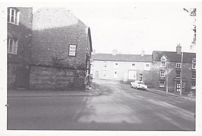
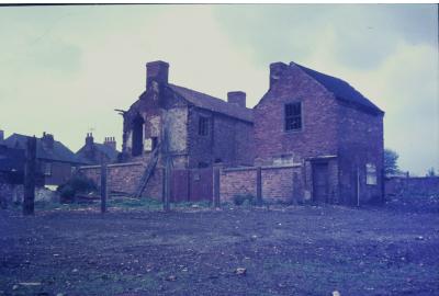
Post Office Yard
Dated: 1970s
Taken by: JH
View of the derelict buildings in Post Office Yard off Potter Street just before demolition. St Werburgh's Church beyond.
Share this image:
View of the derelict buildings in Post Office Yard off Potter Street just before demolition. St Werburgh's Church beyond.

Having taken another look at…
Having taken another look at the photo, it is from the 1970's. I never previously noticed the 'X' upright with 'Branch' horizontal T V Arial, typical of that time, in the top centre of the photo..
Is it indeed Spondon? In my opinion the answer is a firm NO!
Why do I say NO!? Well if the photo was taken from the South-East of the Church then, as previously stated, the Deadman/Watchorn houses would be there, not the run down buildings on the photo.
If the photo is from the South-West, that is Gascoigne Drive/Werburgh Close area then we would see the green area and trees before the Church.
If taken from the East of Church Street, over to Potter Street/Hall Dyke area, we would see the Church Hill houses and the rear of the houses at the bottom of Church Street.
If taken from the North-West of the Church, that is Park Road/Church Mews area, we perhaps would catch a part of the former Vicarage to the right of the photo and the bakery that was to the left of the Church. (Was the bakery Buxton's?)
On none of the four points I have given would we see the mess that is the photograph.
It is not Spondon Church!
Thankyou for your comments…
Thankyou for your comments David. Having had a close look at it myself and using the flagpole the SE corner of the church tower to orientate where the photographers location would have been, could the buildings in the foreground be the derelict cottages on Post Office Lane behind Church Terrace ? These were all demolished around this time. Paul Walpole
Apologies, I had forgotten …
Apologies, I had forgotten 'Post Office Yard'.
Yes, it could well be as you state, a photo taken from the North East of the Church.
I don't know exactly where…
I don't know exactly where this is but my guess is either where West Park meadows is or from where Asda currently is.
Thankyou for your suggestion…
Thankyou for your suggestion Rosaria. I personally think its near the area that you suggest and that it is to the west of St Werburgh's Church but taken from where Church Mews is now. Paul Walpole
First, I have to ask is it…
First, I have to ask is it Spondon? Second, just how old is the photo?
Presuming that it is Spondon, I doubt that it is taken from the area that is now Ayr Close.
From what I can remember, the field there was always cut, for Dick Deanmans use. The house on the right of the picture is in the corect place for the view, but looks derelict when enlarging the photo, I always knew it as occupied by the Deadmans at the Church end, and the Watchorns at the village end, and well looked after they were. The back gardens were well managed, not a mess.
Directly in front of the Church in this view would have been the house and surgery of Doctor Tully. There were some smaller out-buildings infront of his house, from this view, belonging to D D. Thet too were used and maintained by Dick.
If it is Spondon Church, from 'Ayr Close' I am baffled by the tall building at the extreme left of the photo. I doubt very much that it would be the Methodist Chapel, too near the houses on the right.
I hope tha tthis brings some debate.
It could have been taken…
It could have been taken from Werburgh close area before the houses built there now or from the area where it is now church mews
This photo looks like it is…
This photo looks like it is taken from what is now Ayr Close in Spondon towards St Werburghs church. The buildings look like they are the old farm buildings on the bend Lodge Lane to Sitwell Street. I know it says 1970s but it must be much earlier if this is where it is .